The one that everybody asks about
Of the popular local trails, this one is definitely the furthest away. This trail has been featured as one of the best by several national publications. It will take about 1 hour to get to the trail head from St. George. Once you have arrive
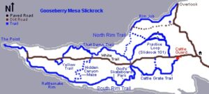
d in the parking lot, make sure that if you are not too sure of your “SPD’s” that you change your pedals. There is a short practice loop for first timers. If you are sure of your ability to clip out quickly, be assured that you will be doing it fr
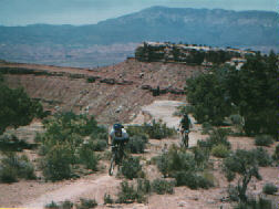
equently the first time around the 11.1 mile loop. It should take you around three hours to complete the loop. If you are looking for technical then you have definitely found it. If you are looking for fast, this is not it. With sudden turns and steep drop-offs you will need to be on your game with this trail. This trail will make you pay for your mistakes, but you will feel rewarded when you have made it back to the parking lot.
North: As you approach Zion National Park in Rockville, turn south (right) on Bridge Road. Continue straight until the road turns right (west) and turns to gravel. Keep left at the fork at 1.5 miles. At 6.2 miles, watch for a road going through the fence on your right at the top of the mesa. 3.6 miles after this turnoff, fork left at the outhouse. Now ignore any smaller branching roads. 1.1 miles later, you’ll cross a cattle guard. Park there. The trail begins along the fence on the left side
South: In Hurricane heading east on Highway 9, turn right at the Highway 59 sign. One block later, turn left and drive out of town. About 15 minutes later, pass a gas station on the left-hand side, then some fields. Watch for a “Scenic Byway” sign 14.8 miles from the turnoff in Hurricane, and turn hard left onto a dirt road. Two miles later, just as you reach juniper trees, the Gooseberry Mesa road turns off on your left. Drive to the trail head as above.
Directions Courtesy of www.utahmountainbiking.com
GPS: N 37 08.500 W 113 10.300′


